
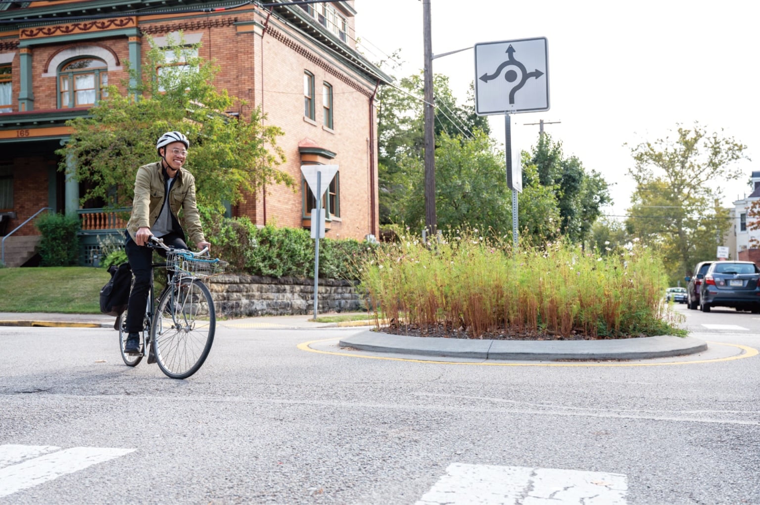
Bike boulevards provide continuous, comfortable bike routes through the local street network. Bike boulevards are characterized by slow motor vehicle speeds and low motor vehicle volumes. Sometimes these are present by the very nature of the street. Still, some design attention is typically needed to reduce speeds, divert motor vehicle traffic, and prioritize bikes at intersections and street crossings.
Cities around the U.S. and Canada have chosen to brand their bicycle boulevards using different names, including neighborhood greenways, neighborhood bikeways, bike-friendly streets, quiet streets, and more. Cities should select a name based on what appeals locally.
Bike boulevards are compatible with a wide variety of land use contexts, densities, and curbside uses, including curbside parking and frequent residential driveways. Generally, bike boulevards are a meaningful addition to a bike network where total vehicle volume is at or below 3,000 per day, and the 95th percentile speed is at or below 25 mph (40 km/h). Where such values are higher, traffic-calming and volume management strategies must be used to establish bike boulevards. Thresholds for AA&A bike boulevards are lower. (See Designing for All Ages & Abilities below).
Bike boulevards should allow bicycle travel in both directions regardless of whether the street allows one-way or two-way motor vehicle operations.
Credit: Bike PGH
Designing for All Ages & Abilities
People tend to bike near the middle of the street on bike boulevards. Along AA&A bike boulevards, those biking should be passed only infrequently by motor vehicles, ideally able to ride several blocks without being overtaken by a motor vehicle driver. The frequency of passing events is a function of motor vehicle speed and volume. With rare exceptions, AA&A bike boulevards include some level of speed or volume management to maintain AA&A conditions. (See Vehicle Speed and Volume Management.)
The bike boulevards that are most comfortable for people on bikes have a target motor vehicle speed no greater than 20 mph (30 km/h); target volumes of 500 vehicles per day; and no more than 50 motor vehicles per peak hour (fewer than one vehicle per minute). However, bike boulevards can successfully facilitate high-quality AA&A bicycle access at motor vehicle volumes of up to 2,000 vehicles per day, as long as 95th percentile speeds are kept at or below 20 mph (30 km/h).
All AA&A volume thresholds should be applied to the total volumes along both one-way and two-way streets. The thresholds are not directional volumes.
| Bikeway | Target Motor Vehicle Speed |
Motor Vehicle Lanes In Same Direction |
Motor Vehicle Volume Per Day |
Motor Vehicle Volume Peak Hour in Peak Direction |
|---|---|---|---|---|
| Bicycle Boulevard |
≤ 20 mph ≤ 30 km/h |
Single lane or none | ≤ 500 - 2,000 | < 50-150 |
Design Guidance


Dimensions
Streets with low motor vehicle speeds and volumes can function as bike boulevards regardless of the width of the street.
For streets with 24 ft (7.2 m) or more of space for two-way motor vehicle traffic, or 15 ft (4.5 m) or more of space for one-way motor vehicle operations, consider additional design treatments. Use design treatments to organize the roadway, maintain narrow motor vehicle lanes, and prioritize two-way biking, including advisory bike lanes, constrained bike lanes, or buffered bike lanes in the with-flow or contraflow direction. Consider opportunities for horizontal deflection through midblock chicanes or midblock hugs (also called chokers).
Along very narrow streets where the shared roadway is so narrow that cars are generally unable to give bikes at least 3 ft (1 m) of space while passing, the target speed should be 10-20 mph (15-30 km/h). Where the shared roadway is so narrow that someone on a bike cannot avoid collision with an oncoming motor vehicle, and where motor vehicle volumes exceed 500 per day, design an alternative route for the contraflow connection.

Markings
Centerline stripes should be omitted along midblock sections and are optional as channelization on intersection approaches.1 2 Existing centerline markings should be removed along midblock sections.
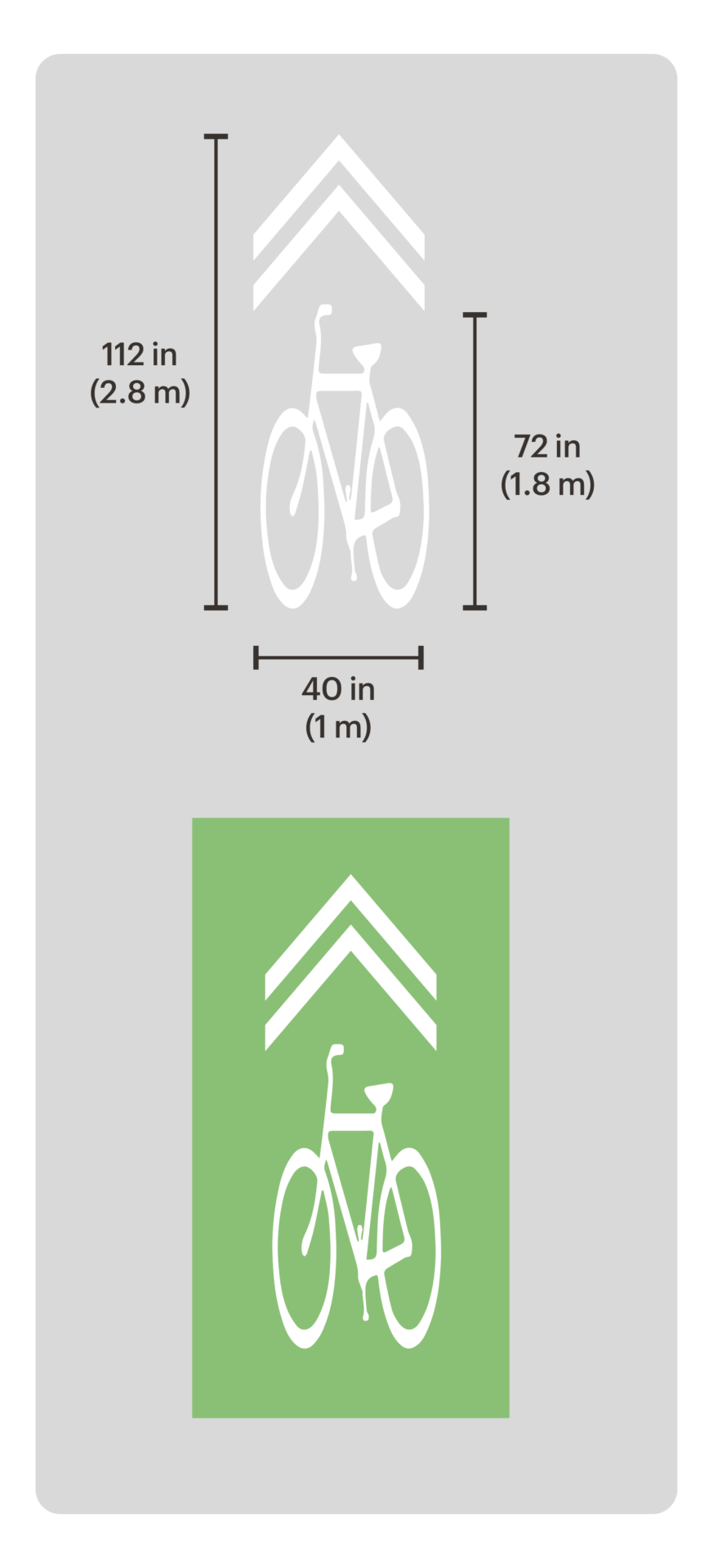
To help people biking stay visible and avoid curbside hazards such as debris or the open doors of parked cars,3 SHARED-LANE markings (also known as “sharrows”) should be placed near the center of each directional lane. Placing the SHARED-LANE markings in the center of the lane between wheel treads may minimize wear. If preferred locally, modified SHARED-LANE markings can be used. If used, they should be used consistently along all bike boulevards in the jurisdiction.
Along block faces without on-street parking, place SHARED-LANE markings at least 4 ft (1.2 m) from the curb.4
Along block faces with on-street parking, place SHARED-LANE markings 12-14 ft (3.6-4.2 m) from the curb to encourage riders to avoid the open doors of parked cars.5
On narrow streets, consider placing SHARED-LANE markings either in the center of the roadway facing each other or with chevrons for each direction of travel pointing from a bike symbol.6
Shared-Lane Markings Minimum Offset Distance from Curb
| Lane Width | Adjacent to Parking | Adjacent to Curb | |||
| 9 ft | 2.7 m | 11 ft | 3.3 m | 4 ft | 1.2 m |
| 10 ft | 3 m | 12 ft | 3.6 m | 5 ft | 1.5 m |
| 11 ft or more | 3.3 m or more | 13 ft | 3.9 m | 6 ft | 1.8 m |
SHARED-LANE markings should be placed approximately every 100-250 ft (30-75 m) in ordinary midblock bike boulevard conditions.7
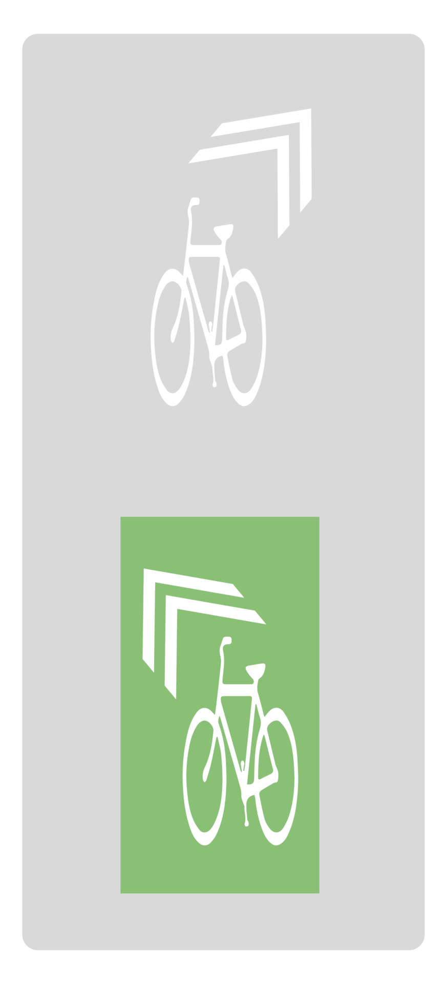
SHARED-LANE markings may be placed more frequently to help riders navigate a turn or shift within the roadway. In these cases, SHARED-LANE markings should be placed so the next marking is easily visible from the last, typically every 10-30 ft (3-9 m). To assist with wayfinding, rotate the CHEVRON marking or the entire SHARED-LANE marking assembly by 30 to 45 degrees to indicate an upcoming turn.
Signs
Standard BIKE ROUTE (MUTCD D11-1) signs, custom bike route signs, or wayfinding signs are used alongside SHARED-LANE markings to help identify the route, guide users through jogs or other non-intuitive connections, brand the bike network, and provide information about intersecting bikeways and nearby destinations.
BICYCLES ALLOWED USE OF FULL LANE (R9-20) signs may be used as supplemental signs.
The wayfinding signs used along a bike boulevard should be integrated into a citywide concept for wayfinding throughout the bike network. (See Bike Route Wayfinding.)

Speed and Volume Management
Speed and volume management strategies must be used to establish bike boulevards. These features can be designed to be compatible with both buses and emergency vehicles. (See Vehicle Speed and Volume Management.)
Mid-block vertical traffic calming, in the form of a series of speed humps or speed cushions, can be used.
Horizontal deflection, from chicanes, mid-block curb extensions (also known as “pinch points” or “hugs”), or islands, may also be used.
Consider using raised crosswalks and raised intersections to supplement other forms of traffic calming. Neighborhood traffic circles and mini-roundabouts are also effective tools for slowing speeds.
At intersections, volume control may be necessary to achieve streets that are comfortable for biking.
Intersections
Proper intersection design is critical to the safety and usability of bike boulevards. Intersections should be designed to maximize the safety and priority of people using the bikeway.
Common intersection treatments include:
- Geometric changes to manage speeds, volumes, and turns, such as constructed medians or hardened lane lines, diverters, roundabouts, neighborhood traffic circles, raised crosswalks, and curb extensions;
- Traffic control devices to improve yielding and stopping, such as stop control for cross-traffic, RRFBs, hybrid beacons, half-signals, and full signalization; and
- Bike lane protection, such as protected bike lane approaches, corner islands, and bike crossing islands.
Intersection control should prioritize the flow of travel on the bike boulevard. For minor crossings, place STOP (MUTCD R-1) signs facing the cross-street rather than the bike boulevard. Consider all-way stop control only as warranted for safety and visibility.

Credit: City of Toronto

Credit: Austin Transportation and Public Works Department
Two-Way and Contraflow Bike Boulevards

Credit: City of Somerville
Bike boulevards along streets with one-way motor vehicle operations should prioritize two-way biking. Accommodating two-way biking on a street that was previously only for one-way operations can greatly expand the reach of the bike network.
Two-way biking can be allowed on streets with one-way motor vehicle operations through signage alone or a combination of signage and markings.
EXCEPT BICYCLES (MUTCD R3-7bP) signs must be installed in conjunction with any sign restricting motor vehicle movements, including DO NOT ENTER (MUTCD R5-1) or INTERSECTION LANE CONTROL (R3-5 through R3-8) signs.
ONE-WAY (MUTCD R6-1 or R6-2) signs may not be used on streets that are one-way for motor vehicles but where bicycling is permitted in both directions.
Warning signage, such as a modified TWO-WAY TRAFFIC (MUTCD W6-3) sign, should be used at any T-intersection or major driveway and may be used along the route to emphasize that the street has two-way bike traffic.
Contraflow bike lanes should be continued for the full length of the street where roadway width allows. (See Constrained Bike Lanes.)
On streets less than 30 ft (9 m) wide, as measured curb-to-curb, consider using contraflow bike lane markings within a minimum of 20-50 ft (6-15 m) of the approach to and departure from intersections.
When using SHARED-LANE markings, include markings in both directions every 50-100 ft (15-30 m).
Intersection traffic controls along the street should also be installed and oriented toward bicyclists in the contraflow lane. Smaller versions of STOP (MUTCD R-1) signs measuring 18 x 18 in (450 mm x 450 mm) and other regulatory signage may be used.8
- “Do not mark a centerline on bicycle boulevard facilities unless it serves as a short channelization device.”
Federal Highway Administration. Small Town and Rural Multimodal Networks. Publication Number. FHWA-HEP-17-024. USDOT, 2016: 2-12. ↩︎ - The MUTCD does not require centerlines on local streets with fewer than three lanes, nor on any streets with less than 6,000 AADT. “Centerline markings shall be placed on all paved undivided two-way urban arterials and collectors that have a traveled way of 20 feet or more in width and an ADT of 6,000 vehicles per day or greater. Centerline markings shall also be placed on all paved undivided two-way streets or highways that have three or more lanes for moving motor vehicle traffic.
Federal Highway Administration. Manual on Uniform Traffic Control Devices, 11th Edition. USDOT, 2023: Section 3B.02, paragraph 01. https://mutcd.fhwa.dot.gov/pdfs/11th_Edition/part3.pdf. ↩︎ - “When sharrows were placed in the center of the lane, a significant change occurred in average bicyclist lateral position, away from the curb and towards the center of the lane. This result was significant both when bicyclists were being passed by motor vehicles and when no passing was occurring, but was more pronounced in the latter instance.”
Brady, John, Jeff Loskorn, Alison Mills, Jen Duthie, Randy Machemehl. Effects of Shared Lane Markings on Bicyclist and Motorist Behavior along Multi-Lane Facilities. The University of Texas at Austin Center for Transportation Research, 2010: 527. ↩︎ - “If used on a street without on-street parking that has an outside travel lane that is less than 14 feet wide, shared-lane markings should be placed so that the centers of the markings are a minimum of 4 feet from the face of the curb, or from the edge of the pavement where there is no curb.”
Federal Highway Administration. Manual on Uniform Traffic Control Devices, 11th Edition. USDOT, 2023: Section 9E.09, paragraph 08. https://mutcd.fhwa.dot.gov/pdfs/11th_Edition/part9.pdf. ↩︎ - “If used in a shared lane with on-street parallel parking, shared-lane markings should be placed so that the centers of the markings are a minimum of 12 feet from the face of the curb, or from the edge of the pavement where there is no curb.”
Federal Highway Administration. Manual on Uniform Traffic Control Devices, 11th Edition. USDOT, 2023: Section 9E.09, paragraph 07. https://mutcd.fhwa.dot.gov/pdfs/11th_Edition/part9.pdf ↩︎ - “The first shared-lane marking downstream from an intersection should be placed no more than 50 feet from the intersection.”
Federal Highway Administration. Manual on Uniform Traffic Control Devices, 11th Edition. USDOT, 2023: Section 9E.09, paragraph 10. https://mutcd.fhwa.dot.gov/pdfs/11th_Edition/part9.pdf. ↩︎ - There is substantial flexibility in the placement of shared lane markings. “At non-intersection locations, the shared-lane marking should be spaced at intervals of not less than 50 feet or greater than 250 feet.”
Federal Highway Administration. Manual on Uniform Traffic Control Devices, 11th Edition. USDOT, 2023: Section 9E.09, paragraph 09. https://mutcd.fhwa.dot.gov/pdfs/11th_Edition/part9.pdf. ↩︎ - Federal Highway Administration. Manual on Uniform Traffic Control Devices, 11th Edition. USDOT, 2023: Table 9A-1. https://mutcd.fhwa.dot.gov/pdfs/11th_Edition/part9.pdf. ↩︎