
Advisory bike lanes (also referred to as edge lane roads) are defined by a narrow central travel lane for two-way general-purpose travel and dashed one-way bike lanes on each side of the street. Motor vehicles operate in yield conditions and use the advisory bike lane to pass oncoming cars when the bike lane is clear.
Advisory bike lanes are typically used on streets that are too narrow to accommodate both marked bike lanes and conventional general travel lanes in two directions, but where some organization of the roadway is desired. They are also useful on slightly wider streets where additional space for prioritizing biking is desired. Similar to bike boulevards, advisory bike lanes are successful where total vehicle volume is at or below 3,000 vehicles per day and the 95th percentile speed is at or below 25 mph (40 km/h). Thresholds for AA&A advisory bike lanes are lower. See Designing for All Ages & Abilities.
Where horizontal or vertical curvature limits visibility of oncoming users, designers should use additional design strategies to slow users, protect the bike lane, and open sight lines. Consider the use of alternative bikeway designs for the corridor.
Advisory Bike Lane Decision-Making Flow Chart 1

Designing for All Ages & Abilities
Advisory bike lanes are most appropriate along low-speed, low-volume streets with operating characteristics similar to bike boulevards. Advisory bike lanes are most common along small residential streets with parking but work in a variety of land use contexts.
Advisory bike lanes are most comfortable for people on bikes where the speed limit is no greater than 20 mph (30 km/h); the volume of vehicles is under 2,000 per day; and no more than 150 motor vehicles per peak hour (fewer than three vehicles per minute).
| Bikeway | Target Motor Vehicle Speed |
Motor Vehicle Lanes In Same Direction |
Motor Vehicle Volume Per Day |
Motor Vehicle Volume Peak Hour in Peak Direction |
| Advisory Bike Lane |
≤ 20 mph ≤ 30 km/h |
Single lane
or none |
≤ 500-2,000 | < 50-150 |


Dimensions
Advisory bikeways are typically implemented on streets narrower than 28 ft (8.5 m) wide, excluding any space dedicated to on-street parking.
The advisory bike lane space should be 5-6.5 ft (1.5-2 m) wide. Avoid advisory bike lanes that are 7 ft (2.1 m) or wider, especially when adjacent to the curb, to limit the likelihood that people will use them as parking or travel lanes.
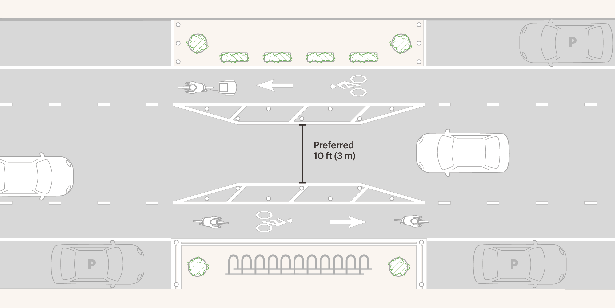
The central motor vehicle space should be 10-15 ft (3-4.5 m) wide, which allows for motor vehicle travel in one direction at a time between the advisory bike lanes. The total combined width of the central motor vehicle space and the bike lanes will provide an effective width of at least 20 ft (6 m) for two-way motor vehicle travel.
The maximum width for the central motor vehicle operating space is 18 ft (5.4 m), providing an effective width of 28 ft (8.4 m) for a motor vehicle to pass another from the opposing direction.
Where more than 15 ft (4.5 m) of space is available for the central motor vehicle lane and the advisory bike lanes are at least 5 ft (1.5 m) wide, additional right-of-way can be allocated to the parking lane. Cities can add a buffer alongside the parking lane or mark the parking lane up to 9 ft (2.7 m) off the curb. Wider parking lanes may be preferable for streets with frequent delivery activity or unique curbside access needs, such as accessible loading.
Where the central motor vehicle lane is larger than 18 ft (5.4 m), constrained bike lanes with buffers may create a more comfortable and predictable biking environment.
Mid-block pinch points (also known as chokers or hugs) can be used to discourage motor vehicles from driving regularly within the advisory bike lanes. These pinch points include short segments of protected bike lane conditions and are wide enough for only a single motor vehicle. Drivers are forced into a yield condition.
Advisory bike lanes adjacent to parking lanes are not recommended where on-street parking demand and use is low. Users may be confused by the mostly empty curbside lane. In these cases, parking lanes should be reallocated to other uses, such as protected or buffered bike lanes.
Markings
Double-yellow centerlines and dashed centerlines must be removed if present.
A broken white lane line is required to delineate the edge of the advisory bike lane adjacent to the motor vehicle lane, typically with 2-5 ft (0.6-1.5 m) segments and 5-8 ft (1.5-2.4 m) gaps.
Use BIKE LANE symbol or “BIKE LANE” word markings (MUTCD Figure 9E-1) in the advisory bikeway.
If curbside parking is permitted, a solid white line should define the parking lane. Use a dotted line or no line at all across minor driveways.
Signs
BIKE ROUTE (MUTCD D11-1) signs or BIKE LANE (MUTCD R3-17) signs may be used to identify the route for biking.
TWO-WAY TRAFFIC (MUTCD W6-3) signs may be used at intersections or driveways to help clarify that the narrow street accommodates two-way motor vehicle operations. This sign should also be used if there is a transition from one-way traffic to two-way traffic.
Temporary or permanent custom signs may be used to show riders and drivers how the street is used. Cities should consider including these signs in their manuals.

Speed and Volume Management
Speed and volume management strategies should be used along advisory bike lanes. These features can be designed to be compatible with emergency vehicles. (See 3.1.2 Speed and Volume Management.)
Mid-block vertical traffic calming in the form of a series of speed humps or speed cushions can be used.
Horizontal deflection, such as chicanes, mid-block pinch points, or islands, may also be used.
Consider using raised crosswalks and raised intersections to supplement other forms of traffic calming. Neighborhood traffic circles and mini-roundabouts are also effective tools for slowing speeds.
At intersections, volume control may be necessary to achieve streets that are comfortable for biking.
Mid-block pinch point
Intersections
Option A
Transition to protected bike lanes or buffered bike lanes prior to the intersection

This is the preferred option for signalized intersections or intersections with higher turn volumes.
Shift the advisory bike lane to the curb using a gradual taper of 5:1 (preferred) or 3:1 (minimum).
Install a double-yellow centerline for a short distance, typically 10-50 ft (3-15m).
Use green high-friction surfacing for 10-25 ft (3-7.5 m) to emphasize the bike lane approaching and departing the intersection. Install BIKE LANE symbols or “BIKE LANE” markings to define the bike lanes.
To prevent illegal parking, install a line of flex posts, planters, or other deterrents.
Option B
Continue the advisory bike lanes to the intersection

Advisory bike lane markings may continue to the intersection, maintaining the yield condition for motor vehicles where the approach is not signalized.
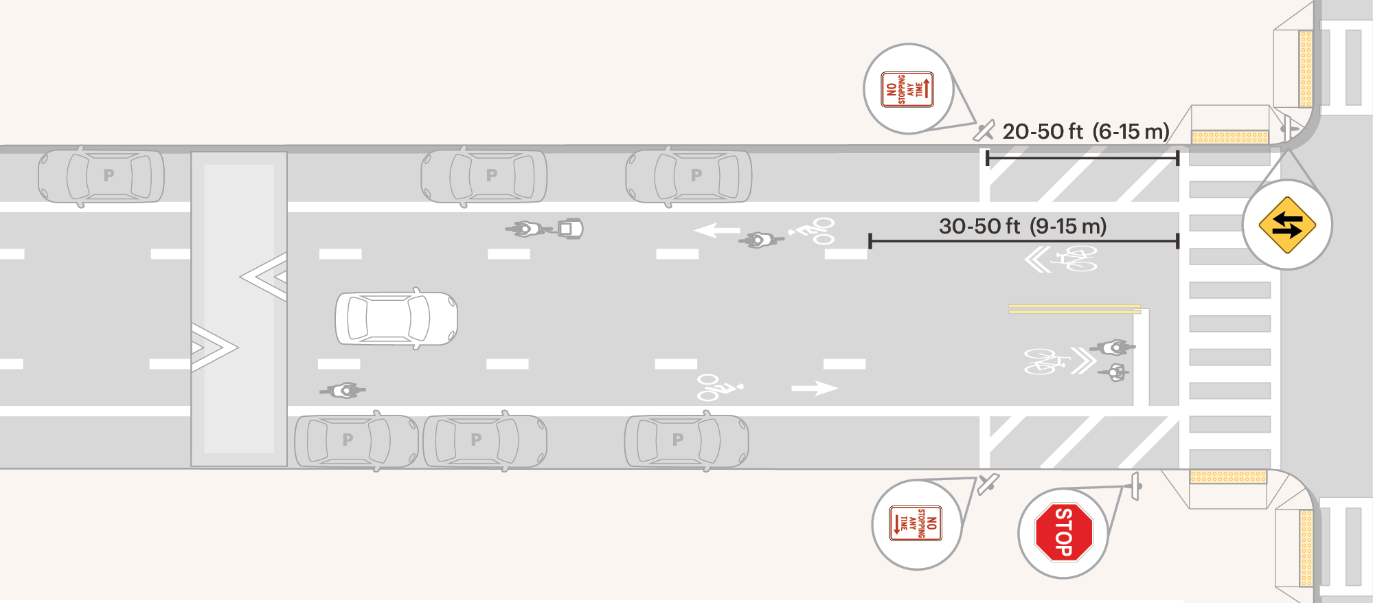
To improve visibility, prohibit parking using a combination of signage (e.g. NO STOPPING (MUTCD R7-4a) signs) and markings within 20-50 ft (6-15 m) from the back of the crosswalk or from the motor vehicle stop line if no crosswalk is marked.
Mark the stop line from the center of the roadway to the parking lane line or daylighting area. Do not use a double-yellow centerline.
Place BIKE LANE symbols or “BIKE LANE” markings at the intersection in both the approach to and departure from the advisory bike lanes.
Option C
Transition from advisory bike lanes to shared travel lanes
Where the intersection is stop-controlled, and there is reasonable concern that motor vehicle drivers would block the intersection to receiving vehicles, the advisory bike lanes may end before the intersection.
Drop advisory bike lane markings 30-50 ft (9-15 m) from the stop line, crosswalk, or intersection to encourage people on bikes to transition from the advisory bike lane to the shared lane in advance of the intersection. Install a double-yellow centerline.
To improve visibility, prohibit parking using a combination of signage (e.g. NO STOPPING (MUTCD R7-4a) sign) and markings within 20-50 ft (6-15 m) from the back of the crosswalk or from the motor vehicle stop line if no crosswalk is marked.
Place SHARED-LANE markings at the intersection, centered in both the approach to and departure from the advisory bike lanes.

Credit: District Department of Transportation
Regulatory status in the United States
Advisory bike lanes continue to be experimental under the 11th Edition of the Manual on Uniform Traffic Control Devices (MUTCD). Cities may file a request to experiment, as detailed in Section 1B.05 of the MUTCD. Locally-funded projects on locally-owned streets are often pursued without official experimentation requests. Engineering judgment is permitted by the MUTCD in cases where a sign, signal, or marking is needed that is not covered by the MUTCD.
Cities should document their rationale for using such a sign, signal, or marking, including citations to this guide or other standards.
- Adapted from the City of Toronto’s On-Street Bikeway Design Guidelines (2023) Toronto Transportation Services. On-Street Bikeway Design Guidelines Chapters 1-3. City of Toronto, 2023. https://www.toronto.ca/ext/digital_comm/pdfs/transportation-services/On-Street-Bikeway-Design-Guidelines.pdf. ↩︎