Cities can improve the usability of their bike networks with clear, consistent, and easy-to-follow wayfinding. Wayfinding helps people navigate unfamiliar places and along new routes. It can be especially helpful for people who are new to biking. Wayfinding is not a substitute for designing safe, comfortable AA&A bikeways.
A comprehensive bicycle wayfinding system consists of signs and/or pavement markings that affirm route-specific decision-making and overall orientation within a city and its AA&A bike network.
Wayfinding systems should be based on principles of:
Clarity and simplicity. Wayfinding should be easy to read and understand, even at a glance, and for everyone, including people with limited literacy or whose primary language isn’t English.
Consistency. Wayfinding should use consistent symbols, colors, and fonts.
Visibility. Wayfinding should be visible to people on bikes, which may require locating it in different places than for people in cars or on foot.
Prior to developing a bike wayfinding system, planners should list types of destinations based on their relative importance within the city and within a given neighborhood. Partner organizations and resident groups should have opportunities to add their own places of importance to the citywide or neighborhood-wide list. Destinations to include in your wayfinding system include:
- AA&A bike facilities, including off-street paths
- Commercial areas
- Transit stations
- Schools
- Parks
- Community centers
- Health care facilities
- Libraries
- Bridges including bridges over highways

Credit: City and County of Denver Department of Transportation and Infrastructure
Mapping these destinations will help planners and designers understand which destinations should be included on any given sign. These maps should document destination types, names (including any abbreviations), and whether the destination is primary, secondary, or tertiary.
Primary destinations, such as the downtown area, may be included on signage up to five miles away. Secondary destinations, such as a transit station, may be included on signage up to two miles away. Tertiary destinations, such as a park, are more local in nature and may be included on signage up to one mile away. Local knowledge should inform when to include, or not include, destinations on signage.
A citywide wayfinding system takes effort to establish and follow. For cities still working to get there, prioritize installing wayfinding on corridors with circuitous or counterintuitive bike routes and in places where bikes and motor vehicles need to follow different paths when approaching the same destination (e.g. a bridge or transit station).
In the United States, cities can consult standards set in the MUTCD. The MUTCD requires the use of a green background for guide signs. While green is the most common color for bike wayfinding, some cities also use blue or purple.
Elements of a Wayfinding System

Credit: Stefanie Seskin
Confirmation signs
Confirmation signs indicate to people on bikes that they are on a designated bikeway and make motorists aware of the bike route.
Include bikeway name and, optionally, destinations.
Option: Include distances and/or travel times to destinations. Travel time may be more helpful to include than distance; use a bike speed of 10 mph (16 kmh) for travel time calculations.
Confirmation signs should be placed at regular intervals along bikeways while avoiding over-signage and clutter. Be sure to place confirmation signs soon after turns to confirm the route. Pavement markings can also confirm that a person on a bike is on a preferred route.
Credit: Allan Crawford
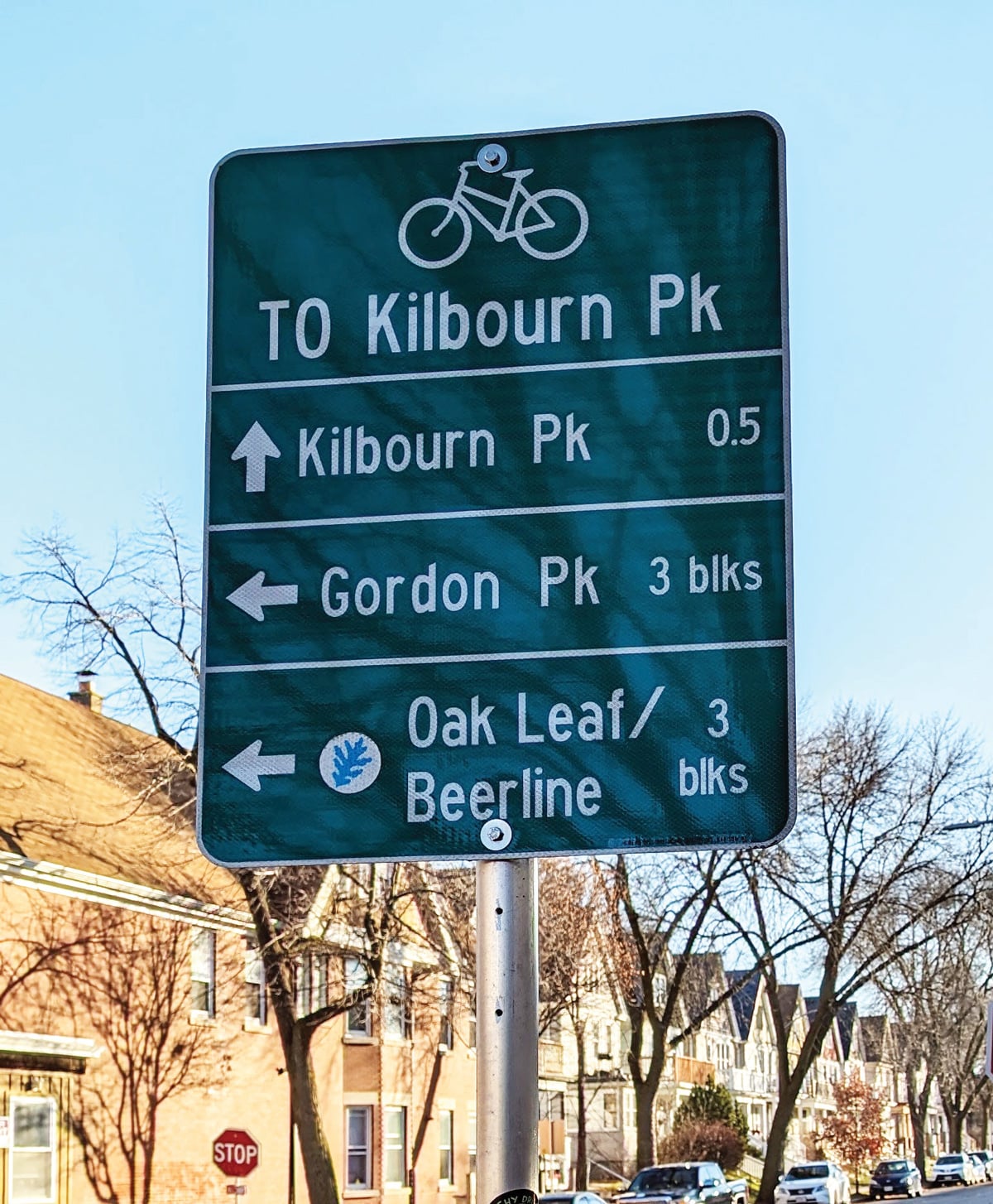
Decision-Making Signs
Decision-making signs mark the junction of two or more bikeways, and to inform people on bikes of the designated bike route to access key destinations.
Include destinations and arrows.
Place the closest destination to each sign in the top slot.
Option: Include distances and/or travel time to destinations is optional. Travel time may be more helpful to include than distance; use a bike speed of 10 mph (16 kmh) for travel time calculations.
Decision-making signs should be placed in advance of all turns on the near side of the intersection. These should also be used to share decision points along the bicycle route, such as where destinations diverge.

Credit: Oakland Department of Transportation
Bikeway Turn Signs
Bikeway turn signs indicate where a bikeway turns from one street onto another street; can be used with pavement markings.
Include destinations and arrows.
Place the closest destination to each sign in the top slot.
Bikeway turn signs should be placed on the near-side of intersections where bike routes turn (e.g., where the street ceases to be a bicycle route or does not go through). Pavement markings can also indicate to people on bikes the upcoming need to turn.

Credit: City and County of Denver Department of Transportation and Infrastructure
Street Name Signs
Street name signs can indicate to both riders and drivers that the cross street is a bikeway.1
Include the street name and a bicycle symbol or other bikeway brand, either as part of the street name sign or as a supplement.
Street name signs on bikeways may be a different color, or the same color, as other street signs.
Apply to all street signs along all bikeways or to street signs on bike boulevards or other shared routes where there is less prominent bike infrastructure.

Credit: Erica Fischer, flickr.com/people/walkingsf
Pavement Markings
Pavement markings are typically used to help reinforce routes and directional signage. They provide route confirmation and can help bikers navigate unfamiliar or unintuitive routes. They may also be useful where signs are difficult to see due to vegetation or parked vehicles. Pavement markings can help brand a route to the general public, including drivers and pedestrians.

Credit: Seattle Department of Transportation, flickr.com/people/sdot_photos
Maintenance
Bicycle wayfinding signs and pavement markings will need periodic maintenance and replacement due to wear. Cities should keep comprehensive inventories of the locations of bike wayfinding signs and the information included on those signs. It may be easier to maintain bicycle-specific wayfinding signs if their typical sizes match those already made in-house or by contractors.
- Use of bike symbols on street signs is restricted under Section 9D.03 of the MUTCD 11th Edition. Cities should document their rationale for using it, including citations to this Guide or other standards.
Federal Highway Administration. Manual on Uniform Traffic Control Devices, 11th Edition. USDOT, 2023: Section 9D.03. https://mutcd.fhwa.dot.gov/pdfs/11th_Edition/part9.pdf. ↩︎