Provide mutual lines of sight between drivers, people on bikes, and pedestrians. Design intersections so that each user has some time and space to slow, stop, or change their path when they see others about to enter their paths. Do not expect all conflicts to be eliminated.
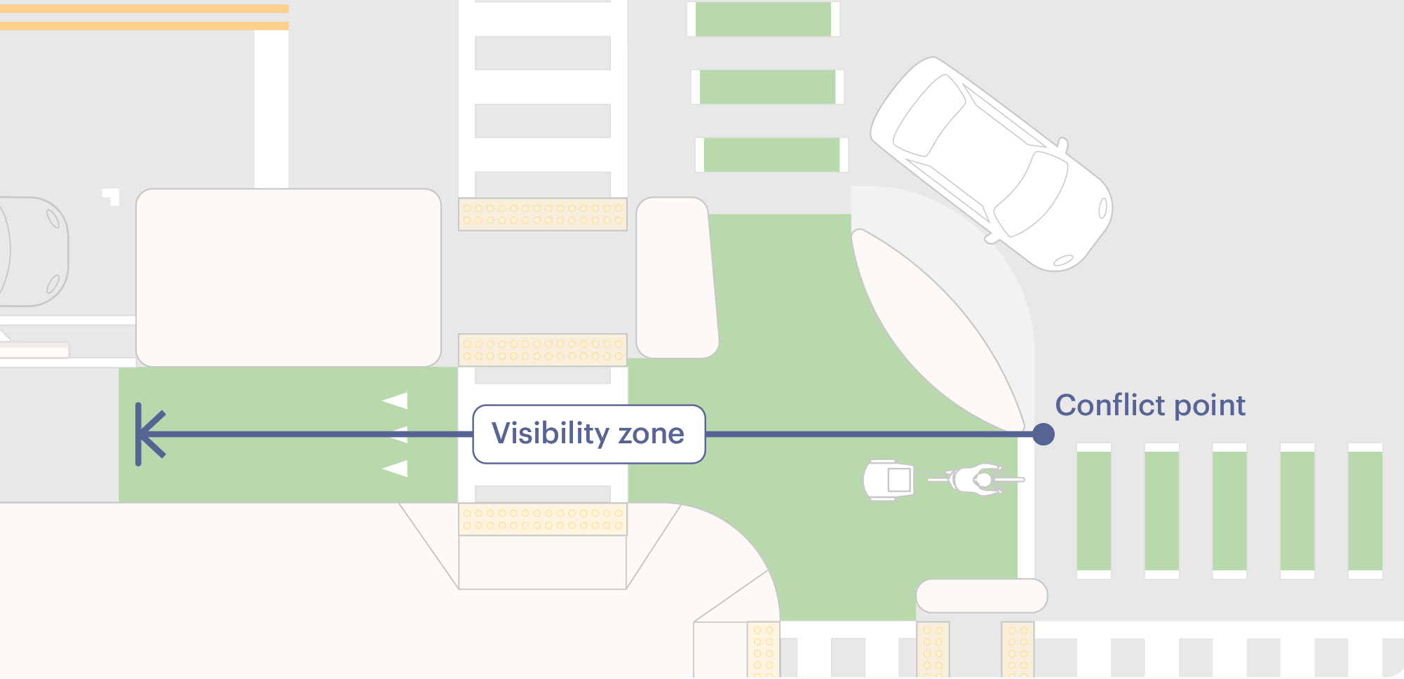
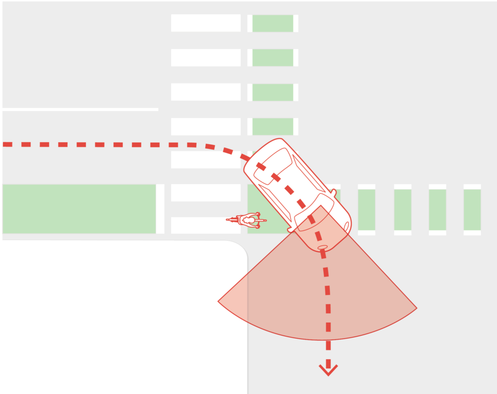
Intersection Visibility Zone

Credit: Salt Lake City
The intersection visibility zone is the area where people on bikes can observe parallel motor vehicles and drivers can observe people approaching in the bikeway. These zones are critical to safe intersections, especially at unsignalized intersections and where turning drivers are permitted to cross an active bikeway.
The intersection visibility zone is distinct from sight distance, which demands sight triangles and stopping sight distances that are often challenging or impossible to achieve in urban or developed environments. Sight distance calculations can also result in intersection designs that encourage speeding and faster turns. Intersection designs should minimize approach speeds and turn speeds, maximize the setback between motor vehicles and the bikeway, and include a visibility zone appropriate to the context.
Approach Visibility Zone
The approach visibility zone is measured from the point at which the motor vehicle movements conflict with bike movements. The length of the intersection visibility zone depends on the bikeway setback, speed of approaching motor vehicles, speed of turning motor vehicles, and bikeway design speed.
|
Street Context The bikeway is crossing: |
Effective Turning Radius | Turn Speed | Recommended Visibility Zone | ||||||
|---|---|---|---|---|---|---|---|---|---|
| Low-usage residential driveways and alleys | < 18 ft | < 5.5 m | Driver expects to stop | 5-10 ft | 1.5-3 m | ||||
| Minor streets or commercial/multifamily driveways with effective turn calming (e.g. raised elements or small radius) | < 18 ft | < 5.5 m | 5 mph | ≤ 10 km/h | 15-20 ft | 4.5-6m | |||
| Minor streets, alleys, or commercial/multifamily driveways with limited or no turn calming | 18 ft | 5.5 m | ≤ 10 mph | ≤ 15 km/h | 30-40 ft | 9-12 m | |||
| All other intersections with turn calming | 25 ft | 7.5 m | ≤ 15 mph | ≤ 25 km/h | 40-50 ft | 12-15 m | |||
These contexts are representative of common urban configurations. Use engineering judgment to determine the necessary visibility zone where additional variables, such as steeper grade or extreme intersection skew, are present.
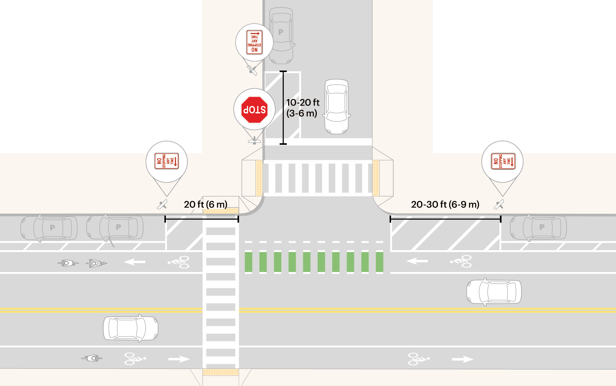
Large obstructions, such as parked vehicles and dumpsters, must be prohibited within the visibility zone. Traffic signals, street lights, bike parking, public seating, shared boarding areas, and shared micromobility stations are often located within the visibility zone without significant consequence. Limit the total number of signs approaching an intersection as the presence of many signs creates sign clutter limiting intersection visibility and reducing the effectiveness of the signs. Transit boarding islands can be part of the visibility zone if the shelter is placed outside the visibility zone. Signal and lighting cabinets should be situated as far as possible from the point of conflict. Trim shrubs and tree branches as needed.
Crossing a Bikeway at an Unsignalized Intersection
When the minor street is stop-controlled and the major street is uncontrolled, the driver crossing or turning onto the major street starts from a stop and continues through the crosswalk, bikeway, and motor vehicle lanes after perceiving an optimal gap. Drivers tend to understand this process as two decisions: one to cross the sidewalk and bikeway and another to enter or cross the roadway. The farside bikeway is often the last consideration for drivers.
The challenge of this maneuver cannot be resolved through increasing sight distances or visibility zones alone. Designers should provide visibility zones on the approach to these intersections as a minimum, and consider applying other speed and conflict management tools, such as reducing travel lanes on the major street and prohibiting through-traffic from the minor street.
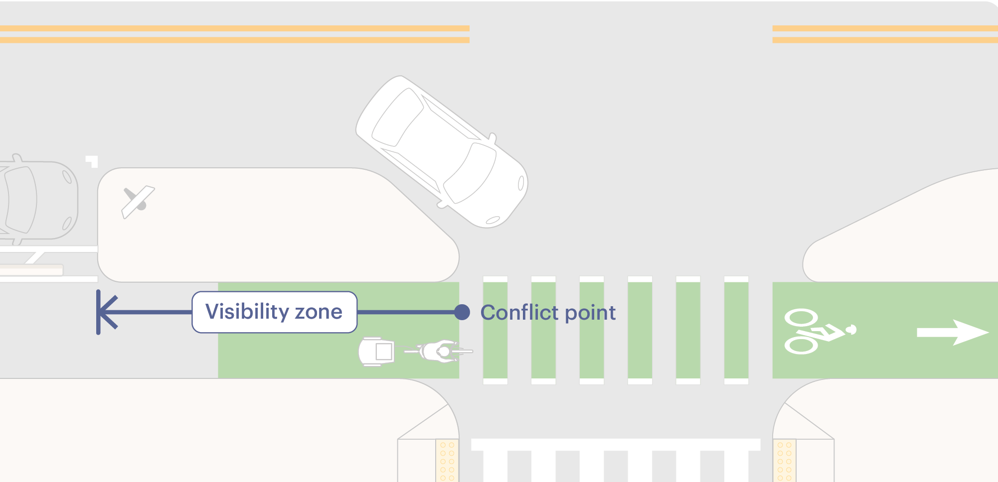
Provide a visibility zone of 10-20 ft (3-6 m) ahead of the bikeway to allow drivers to see bikeway users in both directions. Measure zone length from the stop line or the back of the crosswalk to the point of conflict within the bikeway.
If the bikeway is on a two-way street, an additional visibility zone is needed to give drivers a view of oncoming traffic from the right. This zone should be at least 20 ft (6 m).
Driver visibility of constrained and buffered bike lanes is significantly limited when the bike lane is located between curbside parking and a motor vehicle lane. Provide visibility zones of 20-30 ft (6-9 m) to the left of approaching drivers to ensure they can see oncoming bike traffic. A visibility zone of 20 ft (6 m) to the right enables a clearer view of oncoming traffic in the opposing direction.
Generally, the length of the visibility zone increases with additional lanes and with faster oncoming traffic speeds. Additional factors, such as grade and intersection skew, will alter the length of the visibility zone. Engineering judgment should be documented in these cases.
Crossing a Constrained Bike Lane
Crossing a Protected Bike Lane

Bikeways Crossing from a Minor Street
Bikeways will need to cross streets without bikeways, such as when a bike boulevard crosses a major street with transit priority lanes. Apply visibility zones to the non-bikeway street to help bikeway users properly judge crossing opportunities. Where possible, add bike boxes ahead of the crosswalk. Forward queuing space on the far side of the crosswalk allows bikeway users a protected area from which to look for gaps in oncoming traffic. Visibility zones of 10-20 ft (3-6 m) on either side of the bikeway may improve the ability to see oncoming traffic. Add intersection controls or other geometric strategies to improve the safety of these crossings. (See Unsignalized Intersections.)
Establish Safe Waiting Spaces for People on Bikes
Credit: City of Somerville
Designers can create spaces for bikeway users to stage within an intersection that are clearly visible to drivers.
Forward Queuing Areas

A forward bike queuing area provides an intuitive place for people on bikes to stage after the crosswalk while waiting for a gap in traffic or a green indication. At signalized intersections, forward queuing areas give people on bikes a head start when the signal turns green.
Most forward queuing areas are established with the installation of a corner island. Forward queuing areas should be at least 6.5-7 ft (2-2.1 m) deep to accommodate adult tricycles or cargo bikes. A depth of 10 ft (3 m) or greater is desirable to accommodate a larger volume of bikes, bikes with trailers, or large delivery e-trikes. Forward queuing areas should be at least as wide as the incoming bike lane. Narrowing the corner island can increase queuing space on narrow or crowded bikeways.
Forward queuing areas can also be created in areas that are ahead of crosswalks but otherwise protected from oncoming vehicle traffic, such as within a T-intersection, along a curb where crosswalks are set back from the intersection by at least 6 ft (1.8 m), or adjacent to medians and crossing islands. These queuing areas can function similarly to bike boxes, which are typically placed between the stop line and crosswalk.
Apply green surfacing within the forward queuing area.
If used, passive signal detection should respond to people on bikes and other devices anywhere in the queueing area.
Forward Stop Lines
Forward stop lines, also known as staggered stop lines,1 can improve visibility of the bikeway and provide bikeway users with a head start at signalized intersections by positioning them in front of turning drivers.
Place the bikeway stop line at least 10 ft (3 m) ahead of the motor vehicle stop line.
If used, passive signal detection should respond to people on bikes and other devices anywhere in the queueing area.
Two-Stage Turn Boxes
Two-stage turn boxes allow people on bikes to make turns without merging into vehicular traffic and provide space for forward queuing.
Two-stage turn boxes must be placed outside of conflicting motor vehicle movements. Place a two-stage turn box between the through bike lane and parallel crosswalk if there is no parking lane. Place a two-stage turn box to the left of the through bike lane, aligned with the parking lane, for parking-protected bike lanes.
Outline the two-stage turn box with a 4-6 in (100-150 mm) white line. Install a bike symbol marking and arrow within the box. Green surfacing is optional but recommended.
Design two-stage turn boxes in response to the intersection geometry and usage patterns. Two-stage turn boxes should use the maximum space available, allowing multiple bikeway users to share the space while remaining outside the path of vehicular traffic.
In cities that permit right turns on red signal indications, a NO TURN ON RED (MUTCD R10-11) sign must be installed to prevent vehicles from entering the queuing area.2
If used, passive signal detection should respond to people on bikes and other devices anywhere in the queueing area.
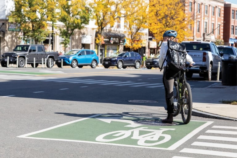
Bike Boxes
Bike boxes are designated areas at the front of traffic lanes that provide people on bikes with safe and visible ways to get ahead of queuing traffic and to position themselves for a left turn. Bike boxes are placed ahead of the stop line and before the crosswalk.
Constrained, buffered, or protected bike lanes should be used on the approach to a bike box, but are not required.3
Bike boxes must be at least 10 ft (6 m) long.4 One side of the bike box may be created with the vehicular stop line. Use a second stop line to establish the front of the bike box instead of using the transverse line of the crosswalk.
Green surfacing within the bike box is recommended. Bike symbol markings must be used in the bike box.
If used, passive signal detection should respond to people on bikes and other devices anywhere in the bike box.

Credit: City of Durham
Create a Bikeway Setback for Additional Visibility
When the bikeway and motor vehicle lane are adjacent to each other with no setback, the bikeway user will be in the blind spot of a right-turning driver if both approach the intersection at the same time and speed. People on bikes continuing in the bikeway need to be prepared for evasive action despite having priority over turning traffic.
Setbacks provide better mutual visibility and allow people on bikes to see turning vehicles before reaching the conflict point. Setbacks can be helpful in all situations, including for drivers and people on bikes traveling in the same direction and for left-turning drivers crossing a bikeway. When a bikeway is to the right of right-turning traffic, creating a bikeway setback can bring the approaching bikeway user out of the blind spot of the right-turning driver. Setbacks are especially useful at intersections where turning drivers are permitted to cross an active bikeway.
Turns with Setback

Turns without Setback
The size of the bikeway setback influences the angle at which motor vehicles cross the bikeway and determines the size and position of the corner island,5 forward bike queuing area, motorist waiting zone, and pedestrian queuing area. Setbacks should be at least 10 ft (6 m), though smaller zones still provide turn-calming benefits when accompanied by a corner island.
A setback is most easily achieved with parking-protected bike lanes or with constrained bike lanes that become protected bike lanes approaching an intersection. The combined width of the parking lane and buffer typically provides at least 10 ft (6 m) of potential setback.
On streets without parking lanes, create setbacks by narrowing the furniture zone or sidewalk and bending the bikeway into that space. Use a 5:1, or 3:1 maximum, taper. Use the visibility zone to begin the taper well in advance of the intersection.
On raised bike lanes, or on bikeways that become raised approaching the intersection, narrow the furnishing zone to bring the bikeway adjacent to the sidewalk. Maintain a different colored surface for the bikeway and add Tactile Warning Delineators to keep the bikeway separate from the pedestrian path of travel. Use separate ramps for the bikeway and pedestrian paths, and apply crossbike markings through the intersection. If space is truly constrained, treat the approach as a shared-use path with one large ramp with a Detectable Warning Surface in a contrasting color. Use a crosswalk in the intersection, unless the legality of people biking in a crosswalk is unclear. (See Don’t Give Up at the Intersection.)
In cases where a bikeway setback is not feasible, other forms of speed management and phase separation or turning movement restrictions (depending on turn volumes) should be evaluated.
- “Staggering stop lines (see Section 3B.19) so that general-purpose lanes stop further in advance from the intersection than the bicycle lane can improve the visibility of bicyclists for drivers of turning vehicles.”
Federal Highway Administration. Manual on Uniform Traffic Control Devices, 11th Edition. USDOT, 2023: Section 9E.02, paragraph 17. https://mutcd.fhwa.dot.gov/pdfs/11th_Edition/part9.pdf. ↩︎ - Federal Highway Administration. Manual on Uniform Traffic Control Devices, 11th Edition. USDOT, 2023: Section 9E.11. https://mutcd.fhwa.dot.gov/pdfs/11th_Edition/part9.pdf. ↩︎
- Federal Highway Administration. Manual on Uniform Traffic Control Devices, 11th Edition. USDOT, 2023: Section 9E.12. https://mutcd.fhwa.dot.gov/pdfs/11th_Edition/part9.pdf. ↩︎
- Federal Highway Administration. Manual on Uniform Traffic Control Devices, 11th Edition. USDOT, 2023: Section 9E.12: paragraph 06. https://mutcd.fhwa.dot.gov/pdfs/11th_Edition/part9.pdf. ↩︎
- “Larger intersection radii were found to reduce turning speeds as they are accompanied by larger corner islands and bigger curb extensions.”
Campbell, Nicholas. “Dissecting the Safety Benefits of Protected Intersection Design Features.” Master’s Project, University of Massachusetts Amherst Graduate School, May 2019. https://scholarworks.umass.edu/cgi/viewcontent.cgi?article=1012&context=cee_transportation. ↩︎