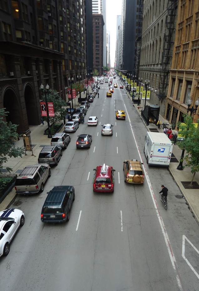
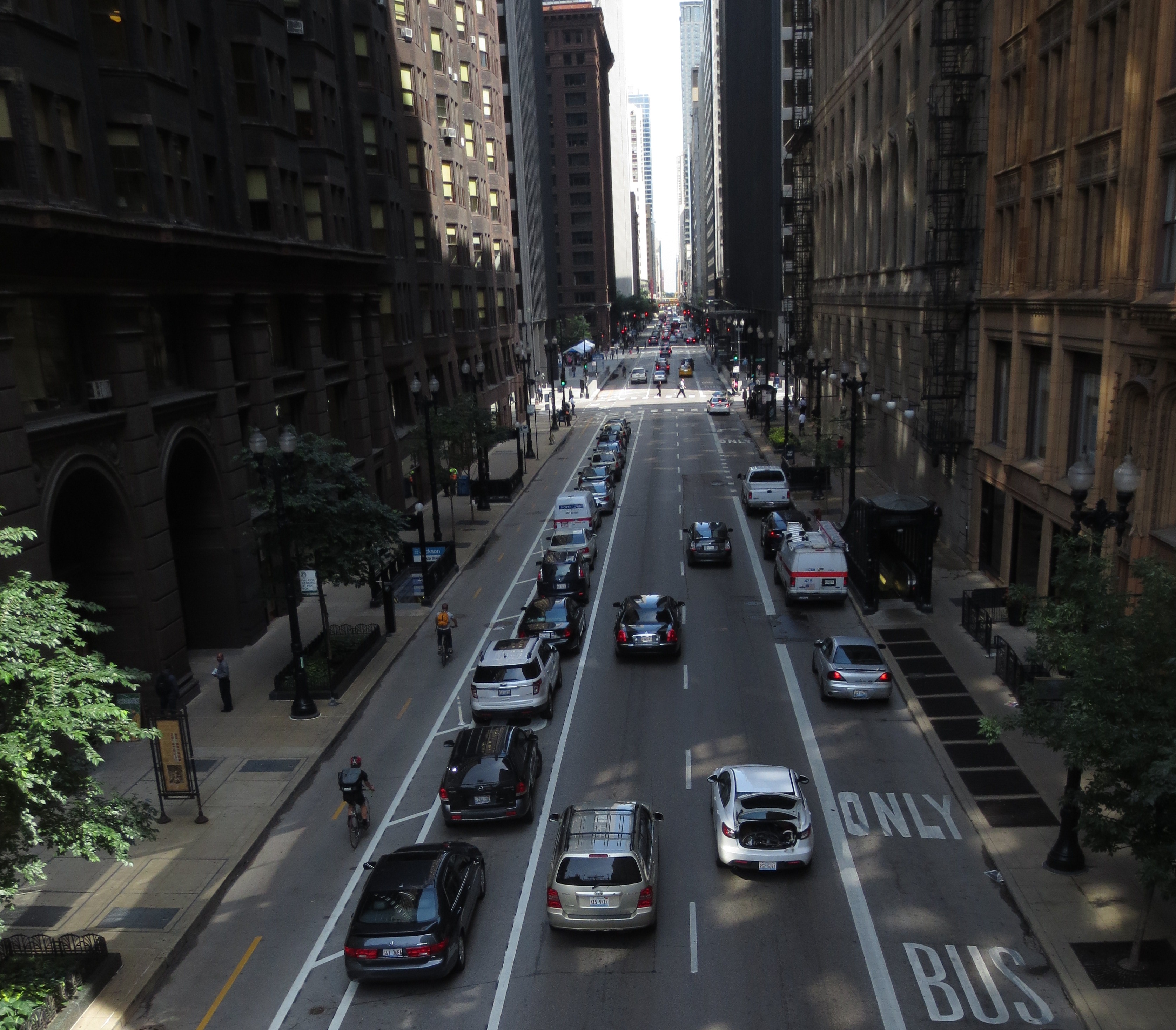
In 2012, Chicago’s Department of Transportation redesigned Dearborn Street, a high-profile, one-way downtown street in Chicago’s central business district, the Loop. Formerly a busy north-south thoroughfare with three vehicle travel lanes, Dearborn Street now has two vehicle travel lanes and a barrier-protected two-way cycle track.
PRIORITIZING COMPLETE STREETS
Upon his election as Mayor in 2011, Rahm Emanuel set a goal to create 100 miles of protected bike lanes within four years. Chicago’s Streets for Cycling Plan 2020 proposed the development of a 645-mile bikeway network throughout the city. This strong leadership and formal planning set the institutional foundation for extensive bike infrastructure development in Chicago.

Dearborn Ave, before
ALTERNATIVES ANALYSIS
Prior to this project, Chicago’s downtown had 32 north-south travel lanes for vehicles, and zero lanes for bikes. In order to select a north-south street for siting a new protected two-way cycle track, CDOT staff conducted an extensive alternatives analysis of downtown streets. Based on the Loop’s geometry and traffic patterns, CDOT focused on Clark Street, a one-way southbound street, and Dearborn Street, a one-way northbound street.
Dearborn St. emerged as the preferred corridor based on a number of factors, including roadway width, average daily traffic counts, vehicles per hour, and rush hour traffic patterns. Analyses showed that removing a travel lane would increase congestion more severely on Clark St. than on Dearborn St.
In keeping with Chicago’s goal of complete streets, CDOT staff also assessed existing transit operations on each street. CDOT preferred that the cycle track be completely separated from transit to avoid conflict. On northbound Dearborn, a left-hand cycle track placed the southbound, contraflow bike lane adjacent to the curb rather than adjacent to any motor vehicles, a preferable design.
CDOT staff also considered the transition at either end of the cycle track. At the southern end of the study area, Clark St. transitions from a one-way street to a two-way arterial, creating challenges for bikes in a two-way cycle track. Dearborn St. dead-ends into Polk Street, providing the opportunity for a much smoother transition. At the northern edge of the Loop, both streets cross the Chicago River: Clark St travels on a 38’ wide bridge, while Dearborn St travels on a 52’ wide bridge, which could more easily accommodate the vehicle lanes and cycle track.
Lastly, CDOT prioritized the alternative that disrupted fewer pay-to-park spaces (which must be replaced if eliminated) and loading or valet zones (which are associated with a specific business and cannot be relocated). Clark St. had 44 total driveways and alleys, while Dearborn St. had 36.
After the alternatives analysis led CDOT to select Dearborn St for redesign, staff conducted a capacity analysis to ensure the Loop’s street grid would still accommodate traffic without causing congestion, gridlock, bad driving behavior, or safety issues with vehicles queueing into upstream intersections. CDOT also conducted public outreach with aldermen and businesses along the corridor. Additionally, CDOT conducted a crash analysis for the years 2006-2010, which revealed that most crashes with injuries occurred at intersections, often involving turning vehicles.
STREET REDESIGN

Dearborn Ave, after
The street redesign covered the 12 blocks of Dearborn St. between Polk St. and Kinzie St., a 1.15 mile stretch. CDOT installed the project in December 2012, using paint for striping. Treating the redesign as a pilot project and using temporary materials allowed CDOT the flexibility to make adjustments to the design if necessary.
CDOT removed one vehicle travel lane and striped a two-way cycle track on the west side of the street, buffered by a parking lane. From east to west, the new street section includes an 8’ parking lane, two 10’ vehicle travel lanes, an 8’ parking lane that becomes a 9’-10’ left-turn bay at intersections, a 3’ buffer, a 4’ northbound bike lane, and a 5’ southbound contraflow bike lane. The buffer is striped with a 6” solid diagonal white line and includes reflective bollards.
North of Congress Parkway, the street section (from east to west) includes a 10’ dedicated bus lane, a 9’ travel lane, a 10’ travel lane, an 8’ parking lane that becomes a 9’ left-turn bay at intersections and driveways, a 3’ buffer, a 4’ northbound bike lane, and a 5’ southbound contraflow bike lane.
New signals and signage provide guidance for bicyclists, motorists and pedestrians. Where the cycletrack intersects with crosswalks, CDOT painted “LOOK” in 3’ letters to alert pedestrians to bike traffic. Where the cycletrack crosses driveways or loading zones, CDOT used green paint to indicate conflict zones. At some intersections, two-stage turn boxes facilitate challenging turns for cyclists. 18 new left-turn arrow signals allow motorists to make safer, more efficient turns at westbound cross-streets. There are 38 new LED bike traffic signals along the corridor, with one far-side and one supplementary bike signal (typically near-side, though sometimes a second far-side signal) at every intersection. Wireless microsensors in the pavement detect the presence of bicycles for signal changes. The bike signals have dramatically improved cyclist behavior at red lights, increasing the compliance rate from 31% to 81%.
Following the pilot project that used temporary materials, CDOT assessed the street’s new design. In summer 2013, CDOT installed preformed thermoplastic pavement markings, additional bollards and signs, green pavement markings, and bridge plates. The total project cost was $563,000, excluding engineering and project management. General Obligation Bond funds covered 90% of the cost, with Tax Increment Financing funds covering the remaining 10%. CDOT plans to extend the project north to Oak Street in the fall of 2013 and is currently evaluating alternatives. Both Clark St. and Dearborn St. are under consideration for the cycle track extension.
MAINTENANCE
The two-way cycle track is wide enough to accommodate both a street sweeper and a plow. The Department of Streets and Sanitation is generally responsible for street sweeping in Chicago, but CDOT performs maintenance in the cycle track. During the winter, CDOT removes snow within 24 hours. Isolated flooding remains an issue, but curbside flooding occurs citywide and isn’t a problem specific to Dearborn St.
INTERAGENCY COORDINATION
CDOT worked with the Mayor’s office to ensure the project’s success. CDOT partnered with the Chicago Police Department to educate officers about changes in enforcement, such as the need to ticket vehicles parked in the cycle track. Though Dearborn St falls under City of Chicago jurisdiction, the Illinois Department of Transportation reviewed intersections with three state roads, including the new bike signals.