
In January, NACTO published the third edition of Urban Bikeway Design Guide, its first update in a decade. The new edition goes beyond a kit of parts to a more complete how-to manual for designing safe, bikeable, inviting streets. Soon, we’ll make the Urban Bikeway Design Guide available for free on our website. In the meantime, we’re posting excerpts each week here on our blog. Can’t wait until the Guide is on our website? Buy it from Island Press, and use code UBDG3 for 20% off.
We’re kicking off this series with a look back—and forward—from NACTO Board Chair Janette Sadik-Khan.
Picture this: The year is 2011. iPhones and Twitter were just becoming a thing, but most of us were still carrying around Blackberries. You could start a political controversy just by wearing a tan suit. Simpler times.
New York City was right in the middle of a bike backlash—the transportation department that I led had only introduced the first parking-protected bike lanes in North America a few years earlier. The idea was simple and borrowed straight from the streets of Copenhagen: Instead of parking cars right against the curb and people riding bikes next to fast-moving traffic, we could just swap the two lanes.
We’re all familiar with the concept today. But in 2011, there were only a scant handful of protected bike lanes in New York and a couple of other cities. You may as well have been making alien crop circles in the street—they were just so foreign to some people.
This was only 13 years ago, long before NACTO was the 100-city-strong network it is today.
Even then, it wasn’t enough to change a couple of streets in New York, or San Francisco, or Seattle. We wanted to change the practice of how streets are conceived, designed, and delivered in every city, on every kind of street, and in every kind of neighborhood.
NACTO was just 15 members when we published the first Urban Bikeway Design Guide, taking the guesswork and improvisation out of building great streets. It gave engineers the ideas, the practices, the materials, and the specs to show how wide a bike lane should be and how to tinker with traffic signals. Importantly, it gave cities permission slips to innovate and to look beyond federal and state manuals for inspiration.
And on a mild October day in 2011, I handed a freshly printed copy of that first edition to the visionary representative Earl Blumenauer, and then into the hands of U.S. Transportation Secretary Ray LaHood.
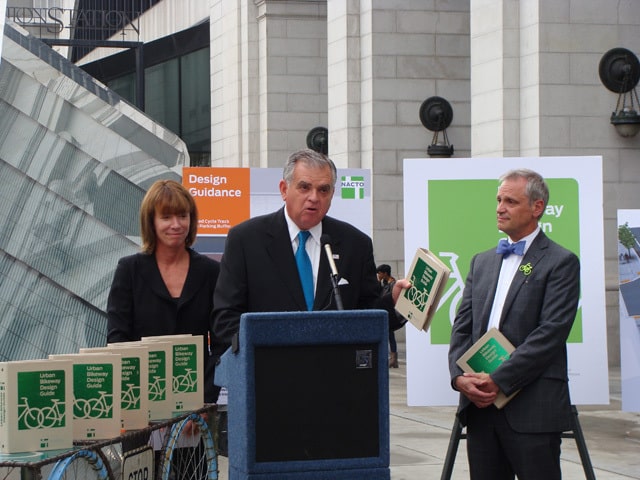
The federal government doesn’t change direction quickly, but when it changes, it can change everything. Within two years, the U.S. Department of Transportation endorsed the Guide, explicitly recognizing the practices that were remaking city streets.
NACTO’s Urban Bikeway Design Guide is the source code for this new era of street transformation in cities from Austin to Los Angeles, Minneapolis to Washington, D.C., Boston to San José, Toronto to Houston, and Denver to Tampa.
These bike lanes, which were hardly anywhere a decade ago are seemingly everywhere today.
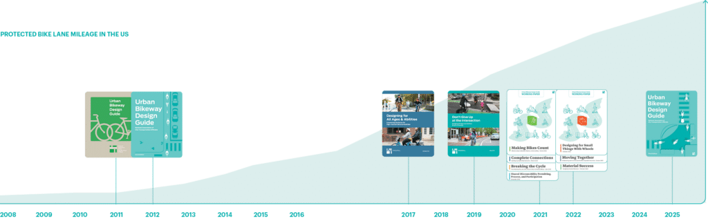
And cities have innovated in all sorts of new ways since then. New designs—bike lanes protected by low curbs, protected intersections, and accessible bus stops alongside bike lanes—are making even the trickiest part of the street safe, comfortable, and inviting for everyone.
Cities also learned how to plan and build complete networks: not just a few premiere lanes here and there, but an interconnected web that gets you from any point to any point in a city. And cities learned ways to plan with communities and not just for them—getting critical buy-in to making streets even better.
With the third edition, we’re ushering in the next chapter in this design revolution. We’re taking everything we brought together more than 10 years ago, along with everything that our member cities—the people making change happen on the ground—have learned, innovated, and created since then. We put it together into a new operating manual for city streets.
Because we need to meet the new transportation moment. While transportation headlines are filled with noise, cities need to keep their eyes on the street and move forward, together when we can and alone when we must. We have to do more to keep building the projects and the streets and the cities we want to see.
NACTO is here for it. We’ve written the book for realizing the full potential of our streets—and our cities.
Adapted from Urban Bikeway Design Guide, Third Edition, published by Island Press
Photo Credits: Header photo of the Keddy Access Trail via City of Hamilton, Ontario


