Location: Los Angeles, CA
Context: Citywide Planning Tool
Participating Agencies: Los Angeles Bureau of Sanitation, Watershed Protection Division; Department of Landscape Architecture, California State Polytechnic University, Pomona; Department of Landscape Architecture, University of California, Los Angeles Extension; USC Price School of Public Policy
Timeline:
- GRASS Phase I: 2013
- GRASS Phase II: 2017
Goals
Capture stormwater: Capture and infiltrate runoff produced by 0.75 inches of rainfall (the design storm in LA, the 85th percentile event) and decrease the peak runoff rate during extreme rain events.
Reduce park poverty: Connect park- poor areas of the city to an active greenway network with ecological, social, and economic benefits.
Provide planning goals: Identify priorities in building out the greenway network, so that future projects will provide the greatest stormwater capture potential, connectivity, and access to park-poor communities.
Overview
The City of Los Angeles’s Bureau of Sanitation worked with three landscape architecture studios at nearby universities to develop a GIS methodology and tool for addressing LA’s urgent water needs, including reliance on remote water sources, persistent drought, and pollution of the Los Angeles River and Pacific Ocean.
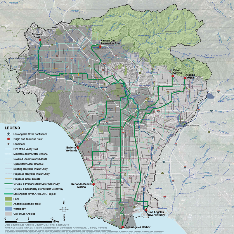
The resulting tool, GRASS (Greenways to Rivers Arterial Stormwater System), provides a citywide green infrastructure solution aimed at managing, treating, reusing, and recharging groundwater throughout the region, while providing recreational space in the form of greenways to disadvantaged communities.
Issues
The majority (approximately 88%) of Los Angeles’s water is imported from sources hundreds of miles away, by an aging infrastructure system serving under extended drought conditions.
At the same time, 75% of Los Angeles’s alluvial soils are covered with impermeable surfaces, preventing significant groundwater recharge during rain events and circumventing natural treatment processes.
Precipitation in developed areas becomes urban runoff, which conveys various sources of pollution. LA’s stormwater flood control system sends this runoff and pollutants directly into the Los Angeles River, which feeds into the Pacific Ocean via local beaches and harbors. Unmitigated, this scenario wastes an invaluable resource and poses human health and economic risks.
At the same time, much of Los Angeles suffers from a lack of parkland and open spaces, with fewer than one-third of LA’s children living within walking distance of a park or playground, revealing an urgent need for more equitable distribution of green spaces.
Design Details
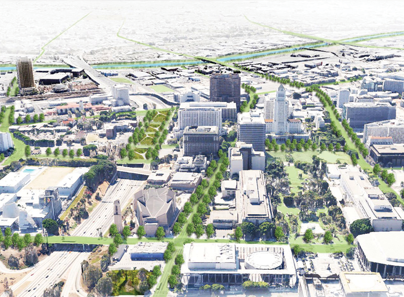
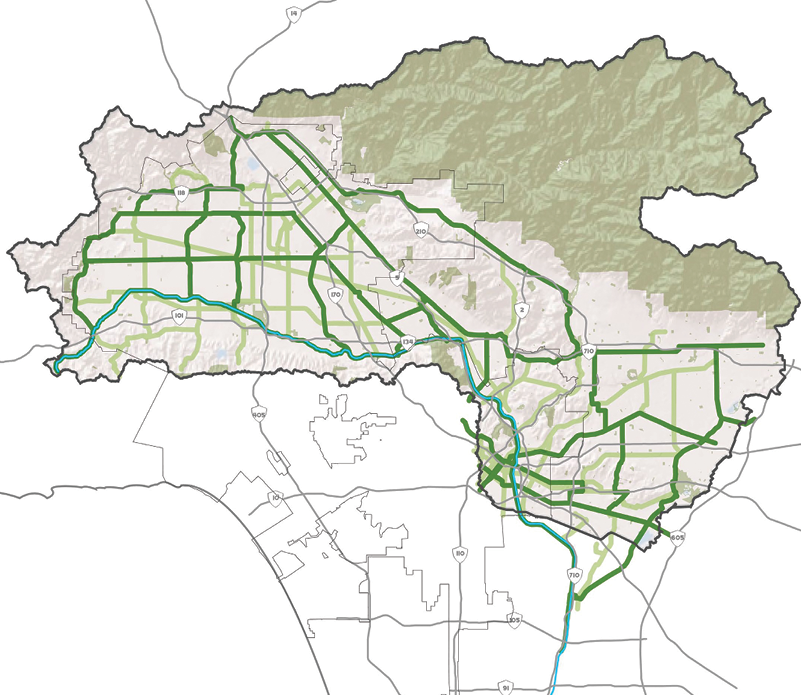
The GRASS Team looked at existing street classifications with wide corridors, bike routes, bus routes, and existing storm drains to create a Regional Greenway Network, which also includes utility and tributary channel easements.
Local agencies and practitioners examined major destinations (schools, parks, and civic institutions), and helped determine priority areas of the Greenway Network. Priority corridors that provide major connections to popular destination points across the grid were identified and used to model the storage capacity of the system.
In addition to modeling the network, arterials were subclassified into five groups to indicate the cross-sectional storage capacities of greenways that could be built based on various soil infiltration rates. The GRASS I greenways were analyzed in terms of their potential to alleviate park poverty, filter industrial stormwater, capture and use or infiltrate water, or serve as a connector between gaps in the network. The GRASS II priority greenways modeled the stormwater capture and treatment potential of fully connective and restored tributaries within the network, and aid project developers in planning for capturing the first 0.75” of runoff from the public right-of-way in a stormwater event.
At the watershed scale, the GRASS approach to building connectivity between projects will assist individual project developers to balance uses (such as irrigation demands) with capture and storage (as may be required for LID mitigation).
While project-scale designs will vary depending on the soils classification of each part of the network, common details include curbside bioretention swales to capture runoff, percolating through various levels of biofiltration before reuse or reaching an underground storage system. Stored water in this system can be used to irrigate trees, supporting tree canopy in a region lacking in it. In extreme storm events, excess runoff in these “offline” systems and infiltration chambers add capacity to the existing stormwater system, and provide increased flood safety, reduced peak flows, and reduced pollutants downstream.
Keys to Success
Use funding opportunities to accomplish multiple goals. GRASS is an ambitious tool that proposes restoration of natural stream benefits through integrated projects and connectivity, allowing for transformational opportunities for neighborhoods across the city. Increasing access to recreational opportunities and open space while accomplishing stormwater infiltration goals also supports regulatory compliance.
Visible public benefits are crucial. In order to gain community and political support, visible benefits are needed for the first phase of ambitious projects. This helps provide momentum for future projects.
Prioritize corridors. With a citywide plan, it is not possible to tackle every potential project at once. A holistic plan that clearly outlines priority corridors in a way that provides connectivity will provide the most benefits in an efficient timeframe.
Outcomes
Developed a mechanism and tool for restoring natural tributary functions through connectivity. The tool identified priority areas and classifications that will enable Los Angeles to build a greenway system that is interconnected, equitable, and high-performing.
Developed a subwatershed masterplan. To illustrate applications, a “high priority” subwatershed, Hazeltine, and four high-priority regional corridors were identified as high-impact case studies for developing the potential of the regional plan.

Urban Street Stormwater Guide
Learn more about transit streets in NACTO’s Urban Street Stormwater Guide.