The City of Portland, OR was awarded a federal grant to develop a comprehensive way-finding system for the Portland Bikeway Network. In April 2005, half of the planned 800 signs had been installed. The remainder of the project was funded using money from the Office of Transportation’s Community and School Traffic Safety Program and a $1 million 2010 federal stimulus grant from the American Recovery and Reinvestment Act (ARRA).
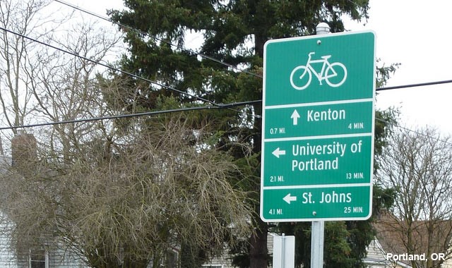
The project identified over seventy destinations throughout the city of Portland, including districts, landmarks, the central library, colleges and universities, parks, and transit centers. Signage was placed at key intersections and decision points along the bike routes. Signs are 24” wide by 32” tall, with a similar width to MUTCD D11-1. They are green with white banners that indicate direction, destination, time, and distance. (Riding times on signs are based on a “no sweat” pace of 10 mph.) The signage is augmented by pavement markings that direct cyclists along the 60 miles of bicycle boulevards throughout Portland. Way-finding signage will help promote cycling in the city of Portland. In the future, signage may also include informational kiosks about cycling in and around Portland.